- info@margadgobitour.com
- (+976) 9901-2659
Magische und faszinierende Landschaften
Die Dramatik und die Unterschiedlichkeit der Landschaften ist sicher einer der Hauptgründe, in die Mongolei zu reisen. Die Mongolei hat grob geschätzt die Größe von Westeuropa; sie ist etwa 4,5mal so groß wie die Bundesrepublik. Die Unterschiedlichkeit kann jedoch nicht größer sein: Wüsten, Wälder, weiten Baum- und Grassteppen, Berge, Halbwüsten, Prärien, Seen und Sanddünen.
Die höchste Sanddüne besteigen
Wie schon erwähnt, ist die Entdeckung der mongolischen Landschaft der Hauptgrund, das Land zu besuchen. Dabei darf man nicht versäumen, die spektakulären Sanddünen der Gobi zu besteigen.
Es gibt ein paar Gebiete mit Sanddünen. Die Khongor Sanddüne gilt als der Vater aller, denn sie erreicht an einigen Stellen eine Höhe von fast 2700 Fuß und erstreckt sich über 90 Meilen in der Länge. Sie zu besteigen ist keine kleine Heldentat, obwohl es Spaß macht und sich lohnt von oben herab zu schauen. Bei Sonnenaufgang oder –untergang gelingen spektakuläre Fotos von den Farben und Schatten der Düne und dem sie umgebenden Land.
Exotische Wildnis
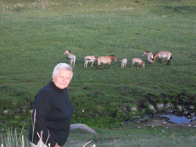
Die Wildnis, die unvergleichliche Flora und Fauna, ist ebenfalls ein Grund, die Mongolei zu bereisen. Und das Besondere ist, dass man nicht einmal weit von der Hauptstadt wegzufahren braucht, um sie zu bewundern. Sie können sich selbst auf den Weg machen oder eine Tour bei uns buchen.
Man sieht wilde Esel, Bergschafe, die persische Gazelle, den Steppenwolf und den Mazaalai, einen kleinen Bären, der nur in der Wüste Gobi lebt. Besonders beliebt für eine Wildsafari ist das Gun-Galuut-Naturschutzreservat, in dem das Argali (berg-) Schaf lebt.
Das Leben der Nomaden kennen lernen
Eine Reise in die Mongolei ist nicht vollständig, wenn man nicht die Kultur und das Alltagsleben der Nomaden erlebt hat. Am verbringt man ein paar Nächte in einem mongolischen Ger (Jurten) bei den Nomaden. Entspannung ist sicher, frische Luft, sauberes Wasser, Natur pur und der weite blaue Himmel über allem. Auf dem Land treffen Sie Leute, die sich über Ihren Besuch freuen und stolz darauf sind, Touristen einen Einblick in ihren Alltag zu geben.
Das Land der verschiedenen Ethnien
24 Ethnien (Volksgruppen) bewohnen die Mongolei. Wenn Sie Nomaden in unterschiedlichen Teilen des Landes besuchen, erleben Sie auch unterschiedliche Bräuche und Traditionen – sogar die Gestalt des Ger oder sein Schmuck unterscheidet sich. Die auffälligsten Unterschiede sind die zu den Kasachen, die im Westen im schneebedeckten Altai leben. Sie sind bekannt als die Adler-Jäger-Leute. Andere sind die Rentierhalter, die im Norden in den bewaldeten Bergen leben. Sie leben in Tipis (ähnliche den Indianerzelten), und ihr Leben ist vollständig der Natur und den Wegen der Rentiere unterworfen.
ALTAI TAVAN BOGD NATIONAL PARK
Mongol Altai Mountain range is one of the three main mountain ranges in Mongolia and the highest peaks in Mongolia are all situated in this range. Range continued more than 900 kilometers. Altai Tavan Bogd and Tsambagarav Mountains are the highest peaks of the West Altai mountain chain. Huiten peak in Altai Tavan Bogd is the highest point of Mongolia. Mount Altai Tavan Bogd is located near the northwestern border of Mongolia . Glacier and ice are permanent in the high altitude areas of Tavan Bogd the peak of Mountain Munh Khairhan is 4326 meter above the sea level. Altai Tavan Bogd protected site in 1996.
 THE AMARBAYASGALANT MONASTERY
The Amarbayasgalant Monastery is located 360 km north of Ulaanbaatar is one of the favorite destinations for visitors. It can be reached by jeep or by a combination of local train and motor vehicle ride. Built in 1727-1736, the Monastery was the second most important in Mongolia after Erdene Zuu Monastery in Karakorum. The Monastery established in 1727-1736 dedicated for Mongolian Religious First Bogd Gegeen. There wer e 27 kinds of big and small temples. According to the Mongolian History in 17th -19th century Amarbayasgalant was a Mongolian greatest pilgrimage Buddhist Center . There were about one thousand lamas living chanted, studied in this Monastery. According to the history Amarbayasgalant was sacked during the repressions of in1930-1940. In 1996 it was nominated by UNESCO as a Heritage Site. After 65 years monks organized "Tsam" Religious dance first time in Amarbayasgalant Monastery in 2002.
 BAGA GAZARIIN CHULUU
Situated about 37km northwest from the centre of Delgertsogt Soum, Dundgobi Aimag. This area of granite surrounded by flat plains is located 1768m above sea level covering 300 sq km area. Around the mountain pass and valley one can see considerable number of ancient graves, khirigsuurs, petroglyphs and monuments besides many gushing springs. There are many sights to see such as a rocky ravine of poplar called Sudutiin am, Jargalant cave, spring of eyesight, Tahilgiin Havtsal /Tahilga canyon/, Ger Chuluu and Khunnu graves.
 BAYAN ZAG FLAMMING CLIFFS
With blazing red sandstone cliffs and plunging canyons this part of the desert looks like something from another world, especially striking at sunset. Bayanzag was made famous when in 1922 American palaeontologist and traveller Roy Chapman Andrews discovered the first nest of dinosaur eggs the world had ever seen.The complete dinosaur skeleton displayed at the natural history museum in Ulaan Baatar was found here. This part of the Gobi is considered a palaeontologist’s paradise because dinosaur fossils can be found so easily close to the surface. Even the amateur eye can easily spot dinosaur fossils when taking a hike through the canyon
 KARAKORUM AND ERDENEZUU MONASTERY
The sites of this ancient capital of Mongolia Karakorum ( spelled also Kharkhorin) and the Erdenezuu monastery with their 108 stupas are undoubtedly at great interest to travelers. Located 370 km away from Ulaanbaatar Elevation is 1600 meters above sea level. Genghis Khan's fabled city was founded in 1220 in the Orkhon valley, at the crossroads of the Silk Road . Building was completed by his son, Ogedei Khan, after Genghis' death, but Karakorum served as the capital for only 40 years before Kublai Khan moved it to what is now Beijing . Following the move, and the subsequent collapse of the Mongolian empire, Karakorum was abandoned and then later destroyed by hordes of Manchurian soldiers. The symbolic ruins of Karakorum monumental walls (400 m of length) with 108 stupas, surround the first Buddhist monastery in Mongolia Erdenezuu Monastery, built in 1586. In 1792, it housed 62 temples and 10,000 lamas; which itself was badly destroyed during the Stalinist purges in 1930s. After democratic movement in 1990, it has become an active monastery again. Turtles carved from the stone marked the boundaries of the complex. Today it retains much of its former glory. Enclosed in an immense walled compound, the 3 temples within are dedicated to the 3 stages of Buddha's life: as a child, adolescent and adult. The main, central temple is called the Zuu of Buddha and has statues of Buddha as a child. Outside the monastery walls are 2 'turtle rocks'. Four of these once marked the boundaries of ancient Karakorum.
 KHAN KHENTII NATIONAL PARK
This is the native land of Genghis Khan and contains many important historical and cultural sites. The park is landscape of transition from Siberian taiga forest to grass steppe. Khan Khentii Mountain National Park is one of the Mongolian natural and historical treasures, declared by UNESCO as world heritage site. Khan Khentii is covered with forests, taiga, and mountain forest steppe. It is the land described in The Secret History of Mongols, a literary monument of the nation, and is a protected area located northeast of the capital city.
 KHERMEN TSAV
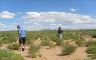
This escarpe, stretched for about 10km, is situated northwest from Gurvantes Soum, Umnugobi Aimag. It is almost 10km broad at its end and reaches about 100-200m in depth at some parts. It looks like a big city ruin from far away. Covering area is 250 sq km and several dinosaur finds were found from the zone. It has not been completely excavated and supposed to have a great possibility of discovering more significant finds. Khermen Tsav is 250km away from Khongoryn Els and 450km from Dalanzadgad. On the way to the Khermen Tsav there are some sights to visit such as Zulganai, Narandaats, Gurvantes.
.jpg) KHONGORIIN ELS
KHONGORIIN ELS
This 180km long range of sand dune is situated at back of Mount Sevrei and Zuulun on west of Mount Gobi Gurvan Saikhan in Umnugobi Aimag. This sand dune is 3-15km wide and 15-30m high. Hundreds of sand dunes will be appeared from top of the Khongoryn Els. The scenery is brilliant with rocky mountains on the south, sand dunes in the centre and a river oasis on the north. Floodwater coming down from Mount Zuulun flows through the sand dune and absorbs into the soil. This absorbed water gives rise to a small river Khongor which flows for about 10km to west along the sand dune. At back of the sand dune there are several tourist camps from where one can reach the sand dune by riding or trekking on a camel. These tourist camps are located 5-17km apart from Khongoryn Els because in a stormy day sandstorm makes it difficult to see surrounding area. But in a windless sunny day the sight is extremely beautiful shimmering as if broadly scattered gold. While travelling in the sand dune, it will be easy to make your way to another top of the sand dune along the ridge. Since Khongoryn Els is a kind of friable sand, it is barely possible to climb through steep parts which will make you feel tired easily. There are many petroglyphs on a rock of Mount Sevrei and one of them is a painting of 4 hunters chasing after 5 mountain goats. Arches and bows held in their arms were ordinary and they are regarded to be belonged to the Bronze Age.
 KHORGO TOGOO
Khorgo extinct volcano (spelled also Horgo) It was established to project the spectacular mountain scenery and endangered species of flora & fauna. It's surrounded by the Khangai Mountains, which reach as 3000 meters above the sea level. Over comparatively small area here there are a dozen or so extinct volcanoes. In the craters some of them are very tiny crystal- clears lakes. The Khorgo crater, situated at an altitude of 2.210 meters with a diameter of 20 meters and depth of 70 to 80 meters, is the most interesting at all. There is no lake in this crater, but clouds of steam jet out it is crevices forming ice moulds in winter , which from a distance look like large flocks of sheep scattered on the mountain. Near the crater there are dozens of small caverns with stalactites hanging from their ceiling and walls. Some time in past volcanic lava flooded the valleys nearby which are covered today with small woods and a great variety of berries and flowers. In the woods there are lots of deer, wild goat and other animals, as well as various kinds of birds.
 TERHIIN TSAGAAN NUUR
An immense mass of white-hot lava once blocked the bed of the River Terkh and it is water formed Lake Terkhiin Tsagaan, which is 16 kilometers in length, 20 meters in depth, and 61 square kilometers in this area. It is situated at an altitude of 2.060 meters. River Suman, cascading from the lake in stormy torrents, pierced through the rocks to form a canyon and several small lakes. The waters of the river are so turbulent that they do not freeze in the severest winter frosts. In the middle of the lake there is volcanic Island is covered with nests made of the fragrant grass Sam khan. Here all day long you hear the hum and cries of birds and the quacking of ruddy shell duck and many types of ducks sand geese &. Red deer , Siberian deer, wild bear, Great Cormorant is common in summer, nesting around the lake.
 KHUVSGUL NUUR Lake Huvsgul "The Dark Blue Pearl "
Huvsgul Lake is known as Dark Blue Pearl among beautiful mountains. This is the perfect place to have vacation, kayaking, canoeing, hiking and trekking. Lake Huvsgul is Mongolia 's largest and deepest lake. Located in the northernmost province, it is the largest tributary stream of Lake Baikal in Russia . 96 rivers and streams flow out of Huvsgul, among them the Egiin River , which then joins the Selenge along its eventual path to Lake Baikal Lake Huvsgul is 136 km long, water beneath 100 meters & 36 km wide, 262 meters deep and is located at an altitude of 1645 m above sea level. Taiga Fauna and Flora, Tsaatan, practicing reindeer breeding are the main attractions for tourist. Fishing and sport fishing are becoming popular in the lake area. Lake Huvsgul is on the important migration route for birds from Siberia , thus facilitating marvelous opportunities for bird watching.
 MENENGIIN TAL Menen steppe
It is the largest steppe in Mongolia which covers 90x60km area. Menengyn Tal is situated 600m above sea level west from Lake Buir in Dornod Aimag. It is one of steppes which is still in its wild nature as well as pastureland being a birthplace of wolf, gazelle and other scarce animals. There is a vast plain known as “Dornod Mongolyn Tal” /Eastern Mongolian Steppe/ stretched from steppe region in Dariganga plateou further until Khalkh River and Khyangan range in northeastern extreme. This vast plain is divided into northern Kherlen steppe and Tamsag steppe. The lowest point of Mongolia is in Kherlen steppe. Yavuukhulan, a famous Mongolian poet, expressed its beauty and uniqueness in his verse as followed:
How unique the sun rising from such a close distance of lassoeing
How unique the ger/house/ appearing from such a far distance of dismounting
Man stone of a nobleman, a queen, a son and a bride
There are 4 man stones named as Nobleman, Queen, Son and Bride in Dariganga Soum, Sukhbaatar Aimag. They were proved to be memorials belong to a same period because of their appearance, clothing and decorations. But, stones used to make them vary. The man stone, known as Bride stone among public, was proved to be a representation of a man as a result of a study by D.Tseveendorj, a director of Archeological Institute in Scientific Academy. According to his explanation it was named Bride, because of the locals’ willingness to bring it close to their life. Deels /outer gown/ of dressed man stones, which belong to Mongolians-ruling period, have a breast on the right side, while that of Turkic period have a breast on left side.
One of many myths related to these man stones is following: Once upon a time, there lived a nobleman with his subjects and relatives in this land. Once he went for hunting with his subjects and let flock of gazelles fall down the steep rock. As a result, they were punished severely by the heaven and his lineage was washed away. So, after that his family was buried with their belongings in this land and man stones for them were built. And it is supposed that the inscription on the Bichigt rock warned descendents not to repeat their action. On the other hand, researchers claim these man stones are memorials for sacrificing golden lineage of Chenggis khan.
 ULAAN TSUTGALAN
This 10m-wide waterfall cascading from height of 24m is situated 132km from Karakorum, Uvurkhangai Aimag. Orkhon Waterfall is formed when Ulaan River, a tributary of Orkhon River, flows down 20-m high cliff into Orkhon River. It flows over 130km through volcanic. During the quaternary period the volcano at the beginning of Tsagaan Azarga River,which takes its rise from Khangai range, erupted and 10km thick layer of basaltic stone was formed along Orkhon valley due to rapid cooling of hot lava from volcanic eruption. A current canyon was formed due to flowing of Orkhon River through this basaltic stone region. There is also a small waterfall, called Baga Khurkhree /Small Waterfall/ northwest from Orkhon waterfall.
 TERELJ NATIONAL PARK
Terelj National Park is the most popular destination and the third biggest protected area in Mongolia . Visitors can take leisurely strolls on meadows carpeted with edelweiss and a dazzling variety of other wild flowers, view fascinating rock formations against a backdrop of pine covered mountains and wander along the wooded banks of a mountain stream. The park is located 80 km away from Ulaanbaatar and is one of the most beautiful places in Mongolia . There are also a huge number of adventure activities such as rafting, riding, hiking, skiing, camping and mountain biking.
 TSAATAN NOMAD FAMILY
The reindeer people live in the North West regions of Huvsgul, which is pretty much like a taiga. Mountains are 3000 meters above the sea level; region has rocks thick grown forests. Herding places are rare and summer is short. However deer and yaks are suitable in the part of the land. Mongolian people called the Reindeer people -Tsaatan people. They are lived in Western and Eastern taiga. Nowadays 14 families are living in the western taiga and 18 families are living in the eastern taiga. The reindeer people move about 6-8 times a year. They use about 5-6 reindeer for transportation and the distance is 150-250km. Also there are shaman mostly tourists want to see them but they not like to see shaman. Because one chosen day they wear their religious customs, clothes like all kinds of metal objects were attached. Often they added so much weight to the custom that someone had to help the shaman to dress. Despite this, the shamans took great leaps and defied laws of gravity whilst under the trance. There are 2 kinds of shamans male (Zairan ) and female (Udgan). Female shaman is more powerful than male shaman.
 TUVKHUN MONASTERY
On the peak of the Undur shireet with 2312 meters high, this locates in boundary of Arkhangai and Uvurkhangai aimags. It was erected by Zanabazar (1 st Bogd Gegen in Mongolia) in 1654 on the smooth grand of the south slope of steep rock with 20 meters high has 14 small temples. He created his famous script "Soyombo" there in 1680. This creation of the temple has enjoyed state protection since 1998 and was registered by UNESCO in the world heritage by grading "The most wonderful valuable object" in 1996
 VISIT NOMAD FAMILY
Mongolia is one of the few nomad countries in the world. Since the Hunnu Empire Mongolians raising their five domestic animals (it is including sheep, horse, cow, camel, and goat) in the broad region of forest, steppe and Gobi desert. Especially they respect their horses. Mongolians see their horse is their best friend. Mongolian nomadic people move into place to place 2-4 times a year as well as it is depending on livestock's pasture. Mongolian nomad people always following their livestock. Because livestock knows where is the best pasture? Herders live in Mongolian traditional dwelling (covered felt) Ger.
.jpg) YOLIIN AM
YOLIIN AM
This mountain gorge took the name of Yol bird which lives around the area. Yol means a bearded vulture in Mongolian. This place is 2800m high above sea level and a 64 sq km area around it was protected. This mountain valley has 40km-long canyon containing a small area of frozen snow melt at the far end. Originally, the area used to be a frozen-like throughout a whole year, but due to the global warming most of the frozen area have been melting recent years. However, some area blocked from sunlight is covered with over 1m thick layer of ice. In the year received sufficient rainfall 4 waterfalls occur. There is a flow of cool air between the canyons without sunlight throughout a year. From bottom of the canyon , the sky appears like a blue narrow strip. Some steep wall rocks are up to 200m.
Yol bird or Mongolian Bearded vulture
Mongolian bearded vulture, a bird belongs to the Bird Sanctuary, is very scarce which lives only in Central Asia. It lives at height of 1500-3000m and its wingspan reaches up to 2,5-3m. This bird has a tuft of hair under its chin, a buff-yellow back and a light abdomen and a head. It builds its nest at least 1700m above the ground and it usually lays 2 eggs in February and feeds mostly from carcasses of dead animals.
 OTGONTENGER MOUNTAIN
One of the Mongolian most sacred mountains, Otgon Tenger Uul Mountain(3905m) is spiritual abode of the gods and an important place of pilgrimage for many Mongolians. Otgontenger Mountain, located about 60km east Uliastai is the highest park in the Khangai nuruu and is now part of the 95.510 hectare Otgon Tenger strictly protected area.

 Eco & Nomadic tour
 Adventure & Sport tour
 History & Culture tour
 Short & Day Trip
 Special & Cure tour
 Winter tours
 Event tour
 Taylor Made tour